AIRSPACE CHART - 1:500 000 (wallpaper, photo paper)
NOTE: Charts are sent only on Polish territory.
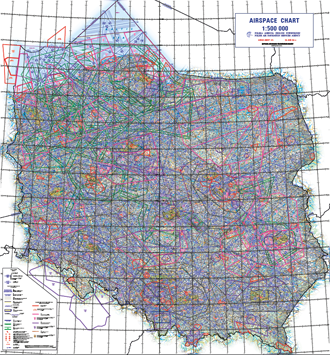
Airspace chart in the scale of 1:500 000. The aeronautical content includes all airspace structures - from GND to FL 660.
The chart shows:
- Airways,
- Terminal Control Areas (TMA),
- Control Zones (CTR),
- Aerodrome Traffic Zones (ATZ),
- Military Aerodrome Traffic Zones (MATZ),
- Constant Military Air Routes (MRTs),
- Low flying Military Air Routes (MRTs),
- Temporary Segregated Areas (TSA),
- Temporay Reserved Area (TRA),
- Feeding Routes (TFR),
- Prohibited Area (P), Restricted Area (R), Danger Area (D),
- Reporting points for VFR flights,
- Reporting points on the FIR boundary.
All heights/altitudes are given in feet.
Unlaminated version.